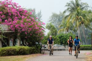
Central Urban Loop Park Connector |
Part of the 300km Park Connector Network by National Parks, the 36-kilometre Central Urban Loop encompasses iconic HDB housing estates in the central region of Singapore including Bishan, Ang Mo Kio, Toa Payoh and Whampoa. The park connector also provides direct access to Bishan-Ang Mo Kio Park, Kallang Riverside Park and Punggol Park.
The Central Urban Loop makes a great running route for long distance lovers without having to do repetitive loops in a small park. With the start point at Toa Payoh Town Park, and end point at Punggol Park, runners in Ang Mo Kio, Hougang and Serangoon can easily access popular spots such as Bishan-Ang Mo Kio Park and Punggol Waterway Park.
The greenery amid the neighbourhoods provides you with lots of recreational options as well as opportunities to observe a myriad of wildlife up close. There are also plenty of hawker delights near Boon Keng, Pelton, Balam Park Connectors , which will tempt you to indulge in them.
The guide to Central Urban Loop can be found here: Central Urban Loop
Route at a glance:
Surface: Pavement
Profile: Moderate
Suitable for night runs? Yes
Parking information:
From Toa Payoh MRT Station, take a 10-minute walk to Toa Payoh Town Park.
By bus
Take bus service numbers 8, 26, 28, 31, 73, 88, 90, 139, 139M, 141, 142, 143, 145, 155, 157, 159, 163, 231, 232, 235, 238 to Toa Payoh Bus Interchange and take a 10-minute walk to Toa Payoh Town Park.


